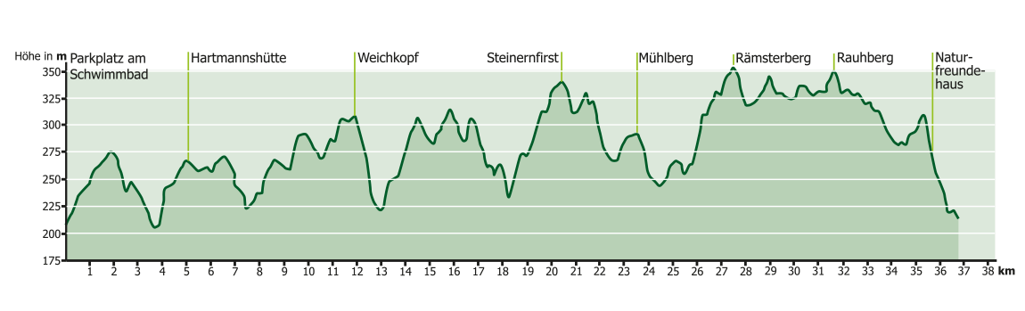
Ober-Ramstadt OR1
37 km
769 Hm
Singletrail: S0
Kondition: K1
Technik:
Ø/max ![]()
Für Familien: geeignet


„
The circuit is characterized by recurring short climbs and descents, typical of the front Odenwald. In terms of landscape, the route is characterized by alternating fields and forests. The route often runs along the edge of the forest, offering impressive views of the hills and valleys.
The circuit is characterized by recurring short climbs and descents, typical of the front Odenwald. In terms of landscape, the route is characterized by alternating fields and forests. The route often runs along the edge of the forest, offering impressive views of the hills and valleys. The riding technique required is fairly easy over the entire route, but the level of fitness required should not be underestimated. After crossing the B 426, the route climbs gently past the model airfield to the Pra-Eiche. From there, turn left along the edge of the forest and, after turning left again, drive through a small opening into the forest towards Suza Pond. As soon as you have passed the pond, continue uphill to the Waldenser (Hartmanns) hut and take a short trail to the back of the Rohrbach sports field. The route leads downhill into the forest, past the forked ponds, on to the Heegwaldbrünnchen on the right and uphill via the Raubhausschneise to the edge of the forest above Rodau. From there you can enjoy a beautiful view of Lichtenberg Castle. After crossing the L 3106 country road, the route runs along the edge of the field. Then turn sharp left into the forest. You reach a meadow valley via a beautifully winding descent that leads past fish ponds. After a few hundred meters, leave the concrete path on the right and take a meadow path uphill to a vineyard. Following the asphalt path, past the Asbach cemetery on the right, you reach the Not Gottes. Turn left and continue over the Brunnenkopf in the direction of Ernsthofen. After turning left again in the direction of Heldenhain, you cross the K 134 district road to the edge of the forest. Soon afterwards you come to an elevated reservoir with a beautiful view of the Otzberg fortress and continue across meadows to the NABU hut. After a steady climb, you reach the parallel MO 1 route, which you follow until you reach the edge of the forest. Now the two routes go their separate ways again. The OR 1 route leads straight ahead across fields with a view of the Neunkirchner Höhe (radar tower) and then to the right through a small wood towards Herchenrode. In the village, turn right between the riding arenas over the Mühlberg to the next village, Ernsthofen. As you drive through the town, you cross the L 3099 country road. Past the church, briefly following Neutscher Weg, turn left behind the castle park to the Buchteich pond at the edge of the forest. After a steady climb, you reach Neutsch and cycle through the village over a hill to Frankenhausen. Behind Frankenhausen, on the Hohe Straße, a magnificent view of the skyline from Frankfurt to the Taunus opens up in good weather conditions. The route continues into the forest over the Rauhberg and at the next crossroads you first head towards Waschenbach. Soon turn right and follow this route to the Vogelherd parking lot. The last stage leads to the right via the Naturfreundehaus Heidenacker and after the descent to the retention basin you return to the start and finish point at the swimming pool. Refreshment stops along the route: sports hall in Rohrbach, sports hall in Asbach, Gasthaus vom Stein in Herchenrode, Gasthaus Sonne in Ernsthofen, Gasthaus Lautenschläger in Neutsch, Naturfreundehaus Heidenacker in Ober-Ramstadt, local restaurants in Ober-Ramstadt.
A bike park is currently being built in Ober-Ramstadt at the sports field of the Georg-Christoph-Lichtenbergschule (approx. 1.3 km from the starting point of OR1). Construction work has already begun. You can follow the construction progress on the following website:
http://bikepark-oberramstadt.de
Suitable for families
Technical requirements: medium
 Michael Becker
Route sponsors OR1
Contact via:
info@mtb-geo-naturpark.de
 Daniel Viehl
Route sponsors OR1
Contact via:
info@mtb-geo-naturpark.de
 Heinz Kehr
Route sponsors OR1
Contact via:
info@mtb-geo-naturpark.de
GPX-Download
(gpx & kml als Zip-Datei)
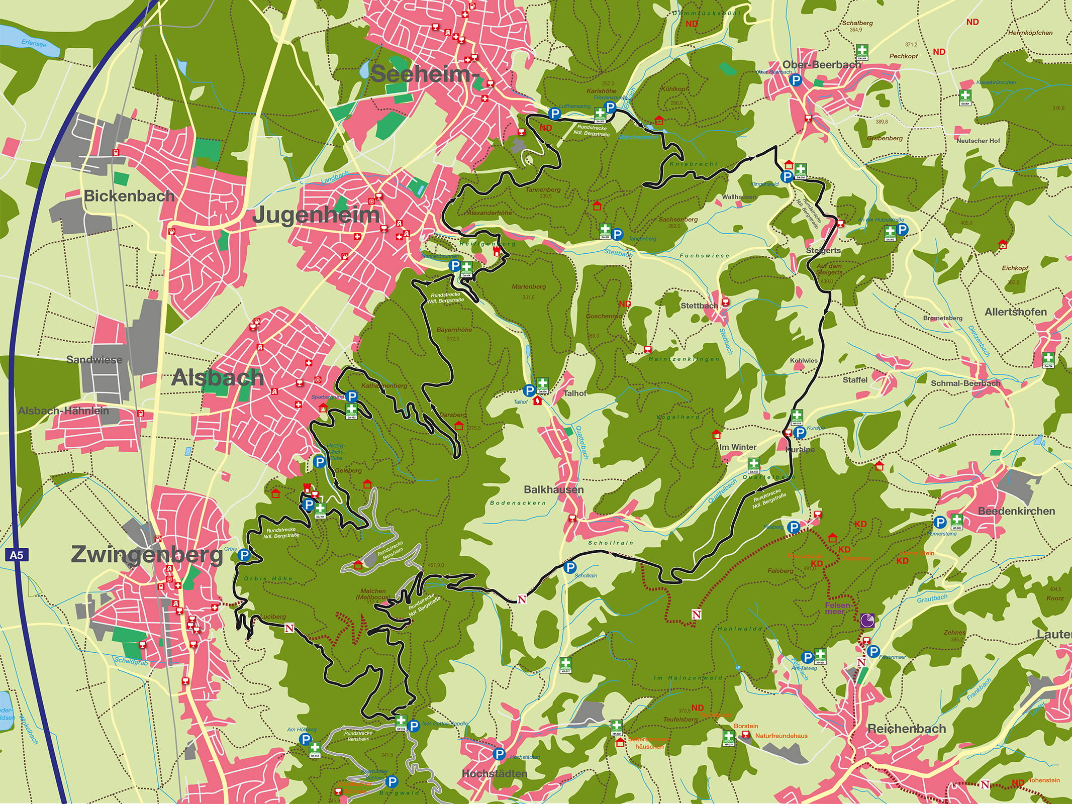
Start Google Maps
OberRamstadt