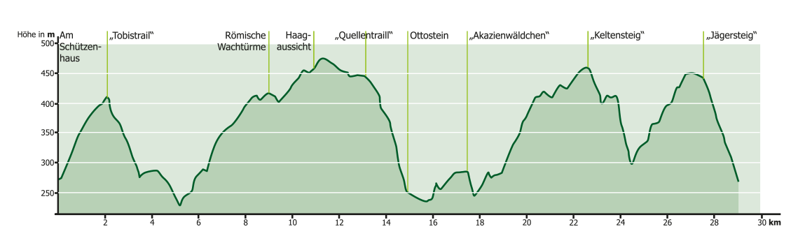
Search
Close this search box.

Miltenberg Mil1

29 km
920 Hm
Singletrail: S2
Condition: K2

Technology:

Ø/max

For families: not recommended

The older, but equally beautiful sister of the Michelstädter Runde. The climb here is steep, but the descent is as interesting as it rarely is. Built-in elements, the legendary Tobitrail and sheer endless flow make the Miltenberg circuit a real gem.
Steep mountain slopes, rugged sandstone formations and magnificent views of the Main valley define the route, which runs through the forest throughout. The route is deliberately chosen so that the mountain biker is always on the mountain flank above Miltenberg during the entire tour. This always opens up new perspectives on Miltenberg and the town seems to be within reach at all times. Bikers can expect a technically and physically demanding route. 29 km with 920 m of ascent. 60% of the circuit is on paved paths, mostly to master the steep climbs. The remaining 40% are natural paths and trails. What makes the heart of an ambitious biker beat faster are the descents – steep, narrow, peppered with bends, past or over rock formations, with small natural drops, berms and bridges, the trails wind their way down into the valley. The start and finish of the tour is the parking lot at the Schützenhaus above Miltenberg. Right at the start, the route leads up the mountain towards Wenschdorf on a natural path that is also used by hikers. This short warm-up phase is immediately followed by a highlight. A narrow trail, “Tobistrail”, leads downhill along the Stephleinsgraben. This section should only be tackled by experienced mountain bikers. Alternatively, there is an easy bypass on gravel paths. Once at the bottom, the trail climbs steeply again in a narrow bend to the next crossroads. The route then follows the gravel path to the Miltenberg-Wenschdorf link road, then runs parallel to the road for a while. After crossing the road, the route turns into an uphill trail, the “Teutonenschneise”. Again, fitness is briefly required. After 500 m, the route is more relaxed on gravel up the Sommerberg. At the top, shortly after the Seboldsruhe parking lot, the trail crosses the previous course of the route and the Limes. Here you can take a short detour to the remains of Roman watchtowers. The route continues on a paved path with no significant differences in altitude past old quarries and the Haagsaussicht with a view of the Main valley and the Spessart. After just under 2 km, things get exciting again. A short trail, the “Funtrack”, ensures a good mood. Small berms, short successive waves and a slalom course between trees make this area a playground for bikers. The route continues on natural paths and trails to the “Quellentrail”. The trail leads steadily downhill, partly in narrow serpentines, over rock slabs and root sections. After a short breather at the Ottostein and a magnificent view of the castle, the town and the River Main from Miltenberg’s Schloßberg, the route continues uphill on partly natural and paved paths. A short serpentine trail through the “acacia grove” interrupts the pedaling upwards. At an altitude of 452 meters, the route crosses the Ringwall, a former Celtic site, and leads to the “Keltensteig”. This downhill is even steeper, more rugged and more daring than the “Quellentrail”. As with the “Tobistrail” and the “Quellentrail”, a lot is demanded of the biker in terms of technique. Now follows the last ascent on paved paths to reach the last trail, the “Jägersteig”. The descent on the “Jägersteig”, an old path that is also used by hikers, leads the tour back to the starting point.

For families: not recommended
Technical requirements: high

Stefan Ruprecht
Route sponsor Mil1
Contact via:
info@mtb-geo-naturpark.de

GPX download

(gpx & kml as zip file)

Start Google Maps