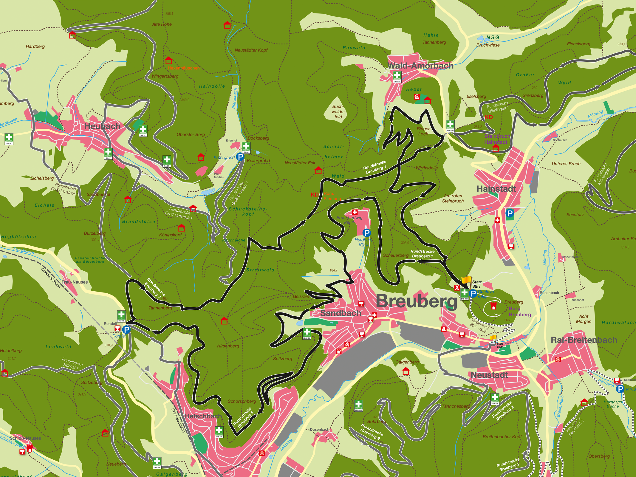
Equipped with many natural trails through hollow paths and border paths, the tour starts directly below Breuberg Castle. After the Sandbacher See lake, there are several challenging hairpin bends in the direction of Hetschbach. In general, the proportion of routes on asphalt is very low.
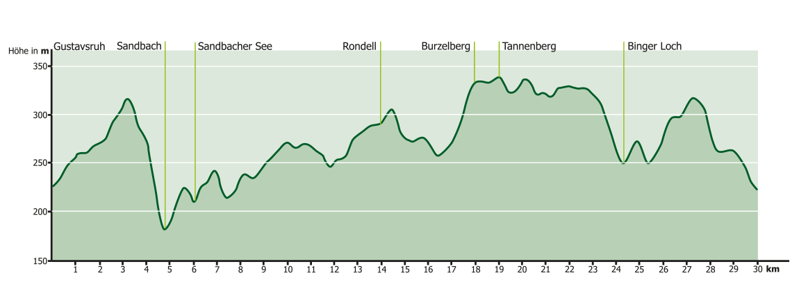
The approx. 30 km long route with an elevation gain of approx. 730 meters starts and ends opposite the “Gustavsruhe” parking lot above the youth campsite directly below Breuberg Castle near Breuberg-Neustadt. From there, the route leads along forest paths in the direction of Sandbach, then above the AHG clinic into a descent through a hollow trail down to the “Kiesbuckel” on the outskirts of Breuberg-Sandbach. After an ascent across meadows, with wonderful views of Breuberg Castle and the districts of Breuberg, the route continues along forest paths and trails and meadow paths towards Sandbacher See. There is also an entry point to the route, with start and finish, at Sandbacher See. Behind the Sandbacher See lake, you cross a small footbridge and then head towards Höchst. Then in serpentines over several partly. challenging trails in the direction of Hetschbach to the Rondell parking lot on the B45. Here is another entry point for the start and finish. From here along trails and paths parallel to the B45, first below (great views to the west and of the Otzberg fortress) and then above the Silberwald nature reserve quarry back towards Sandbach. From there via forest paths and trails to the saddle between Hainstadt and Wald Amorbach. Here you have the possibility to change to the mountain bike trail “Mö1” from Mömlingen (approx. 200m connection). A short asphalt track near the youth campsite leads over a steep descent near Wald Amorbach, then over trails and forest paths towards Hainstadt and back to the starting point at Breuberg. There are almost no roads to drive on or cross on this route. The route was chosen and laid out with consideration for nature and forestry as well as hunters, hikers and walkers.
Um dir ein optimales Erlebnis zu bieten, verwenden wir Technologien wie Cookies, um Geräteinformationen zu speichern und/oder darauf zuzugreifen. Wenn du diesen Technologien zustimmst, können wir Daten wie das Surfverhalten oder eindeutige IDs auf dieser Website verarbeiten. Wenn du deine Zustimmung nicht erteilst oder zurückziehst, können bestimmte Merkmale und Funktionen beeinträchtigt werden.
Funktional
Always active
Die technische Speicherung oder der Zugang ist unbedingt erforderlich für den rechtmäßigen Zweck, die Nutzung eines bestimmten Dienstes zu ermöglichen, der vom Teilnehmer oder Nutzer ausdrücklich gewünscht wird, oder für den alleinigen Zweck, die Übertragung einer Nachricht über ein elektronisches Kommunikationsnetz durchzuführen.
Vorlieben
Die technische Speicherung oder der Zugriff ist für den rechtmäßigen Zweck der Speicherung von Präferenzen erforderlich, die nicht vom Abonnenten oder Benutzer angefordert wurden.
Statistiken
Die technische Speicherung oder der Zugriff, der ausschließlich zu statistischen Zwecken erfolgt.Die technische Speicherung oder der Zugriff, der ausschließlich zu anonymen statistischen Zwecken verwendet wird. Ohne eine Vorladung, die freiwillige Zustimmung deines Internetdienstanbieters oder zusätzliche Aufzeichnungen von Dritten können die zu diesem Zweck gespeicherten oder abgerufenen Informationen allein in der Regel nicht dazu verwendet werden, dich zu identifizieren.
Marketing
Die technische Speicherung oder der Zugriff ist erforderlich, um Nutzerprofile zu erstellen, um Werbung zu versenden oder um den Nutzer auf einer Website oder über mehrere Websites hinweg zu ähnlichen Marketingzwecken zu verfolgen.