Gorxheimertal Go1
21 km
1000 Hm
Singletrail: S1
Kondition: K2
Technik:
Ø/max ![]()
Für Familien: nicht empfehlenswert


„
You should bring some practice with you, then the interesting and challenging Go1 is easy to master overall. It runs through four valleys and can be easily combined with the Birkenau and Absteinach routes. One highlight is the optional Buchklingen Trail.
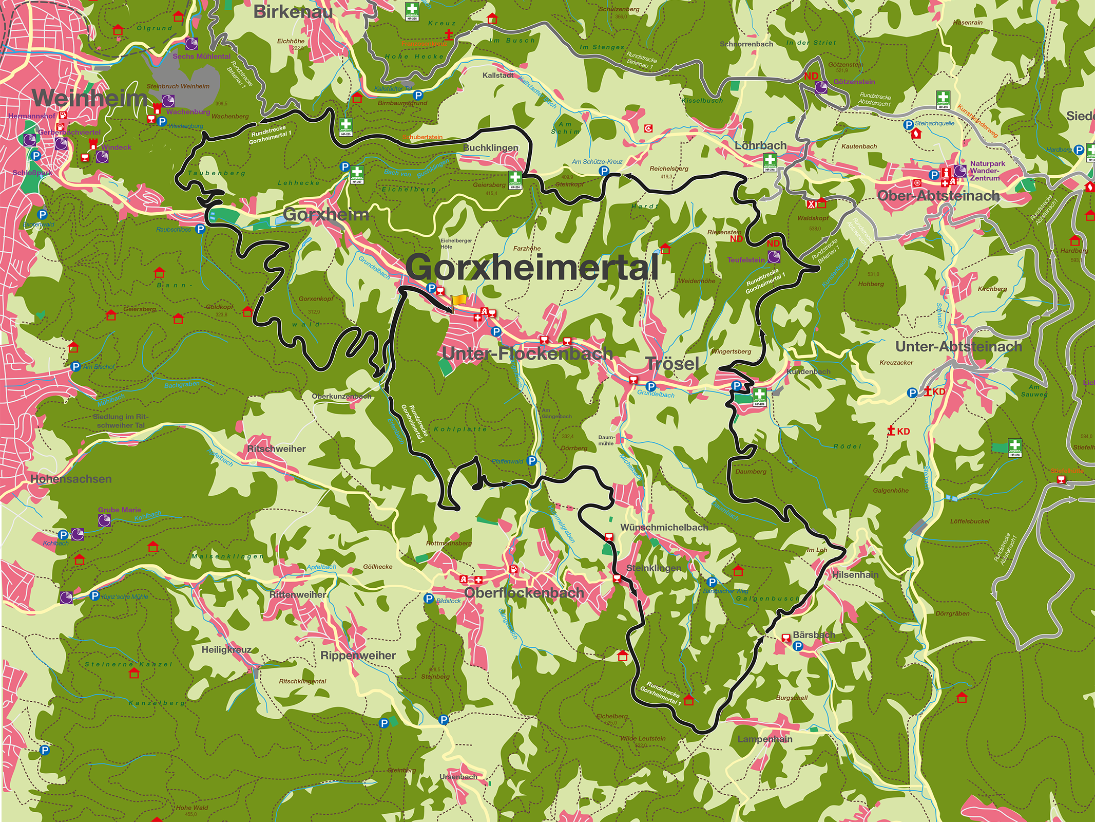
With an elevation gain of almost 1000 meters and a length of 32 km, the interesting and challenging Go1 route is manageable for hobby cyclists with a little practice. It comprises four districts, two federal states and runs through 4 valleys. It also serves as a link between the Baden-Württemberg route network and connects to the existing Birkenau, B1 and Abtsteinach, A1 routes. The start and finish of the tour is Germaid-Fitz-Platz at the town hall in the center of Gorxheimertal. The route first leads towards Ober-Kunzenbach, past the „Gypsy Bridge“, before following the Erlenbach uphill towards Oberflockenbach in the Weinheim district. Once on the Höhenweg in the direction of Oberflockenbach, the route leads towards the Unter-Flockenbach sports field, before turning onto the first descent into the Gängelbach valley on the K 16 district road between Unter- and Oberflockenbach. After crossing the K 16, the route leads along pastures and orchards up to the outskirts of the neighboring municipality of Steinklingen. The village of Steinklingen and the K 17 must be crossed. The route leads past the „Suppenschüssel“, a few 100 m over asphalt, and then along the Eichelberg up to „Hohestraße“, above the village of Bärsbach, in the Heiligkreuzsteinach district. There are about 200 meters of altitude to overcome from the crossing of the K16. The route continues to Hilsenhain, past the „Galgenbusch“ – where you have a fabulous view of the Rhine plain as far as the Palatinate Forest – to the „Zigeunergrab“, the second highest point of the entire tour at an altitude of 460 meters. From here, a rapid descent of over 200 meters in altitude takes you down the Daumberg into the Gorxheimertal, where you have to cross the L 3257 country road to tackle the ascent on the opposite side. This descent is a short rest before you climb to the highest point of the tour, the natural monument „Teufelstein“, at an altitude of 480 m. From the „Teufelstein“, the trail, on which you are rewarded for your efforts for the tough climb with a great view, continues along the edge of the forest across the Birkenau district towards the „Schütze-Kreuz“. There, the route first turns in the direction of Gorxheimertal, with a fantastic view of the municipality, and then goes around the „Steinkopf“ hill in the direction of Buchklingen. In Buchklingen you then have to cross the K 15 to get past the cemetery onto the Höhenweg in the direction of „Wachenburg“.
At the highest point above Buchklingen, the Birkenbüschel, you have a magnificent view of the Rhine plain and Mannheim. It is also the starting point of the Buchkling Trail. The colors of the following direction arrows, familiar from skiing and MTB sports, indicate the difficulty. The Buchklingent trail is marked „blue“ at the beginning and later „red“, which requires riding technique in any case. There is also a „green“ route in parts which leaves out the difficult parts and shortens them. Section 1 of the trail leads from Birkenbüschel down to Böhm Hütte on a bumpy dirt track. From there, the trail continues through the forest along the ridge to the trail gate; the start of the challenging „red“ part of the Buchklingent Trail, which begins with section 2. From here, you can continue to follow the „green“ trail along the forest path to the Friedrichshütte. The „red“ trail corresponds to the single trail scale S1 to S2. Berms, natural drops and steep, bumpy or rooty sections require protective equipment and advanced riding technique. After each section, you can return to the „green“ route by turning left onto the respective forest path. The trail ends above Birkenau and then leads to Friedrichshütte.
A forest path follows, first in the direction of Wachenburg and then, sharp left, down into the last valley and the lowest point of the route, the forest swimming pool in Weinheim. Here you have to cross the L 3257 country road once again to tackle the final ascent of around 150 meters. The route then leads past the swimming pool, with a great view of Gorxheimertal, then around the „Gorxenkopf“ hill and ends with a final crisp descent at the „Zigeunerbrücke“ bridge. From there, the last kilometer is on a flat asphalt road back to the starting point.
For families: not recommended
Technical requirements: medium

 Andreas Michael
Route sponsor Go 1
Contact via:
info@mtb-geo-naturpark.de
 Rainer Heckmann
Route sponsor Go 1
Contact via:
info@mtb-geo-naturpark.de
GPX-Download
(gpx & kml als Zip-Datei)
Start Google Maps
Gorxheim Valley