Brensbach-Wersau BW1
27 km
630 Hm
Singletrail: S0
Kondition: K1
Technik:
Ø/max ![]()
Für Familien: geeignet


„
An enjoyable tour for the whole family with few vertical meters and low technical demands. The descent into the Wünschbach valley is nevertheless impressive. The reward here: A fast and rocky descent. However, large parts of the route are laid out on pleasant forest paths.
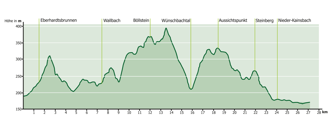
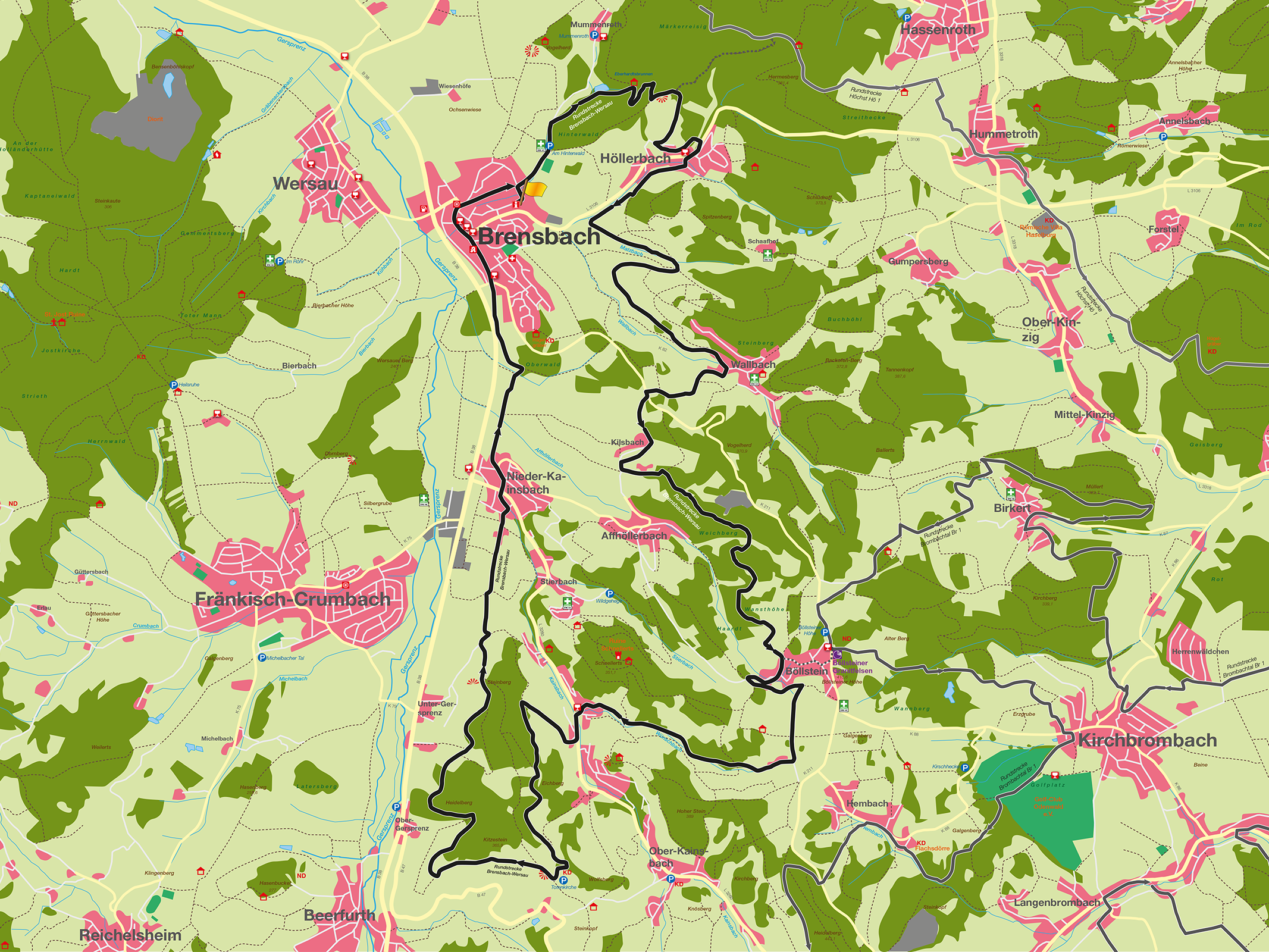
Our 27-kilometre route, on which we have to climb 630 meters in altitude, takes us past the sports field towards Mummenroth. 300 m after the sports field, we turn right, ride through a beautiful shady forest past the Hinterwaldteich pond and then turn right again at the refuge at the Eberhardtsbrünnchen. Depending on your fitness level, it will now be more or less strenuous until you reach a weekend home. Behind the weekend house, a small forest path leads off to the right and rewards us with a beautiful descent to Höllerbach. Once in the valley (warning sign), turn right onto the L 3106 and after approx. 200 m turn left into Schafhofweg, after 50 m turn right again. We are now on the road that runs parallel to the L 3106 towards Brensbach just above Höllerbach. On a gravel path to the left of the Höllerbach we ride to the tributary of the Matzbach. We now cycle along the Matzbach (approx. 800m), mostly slightly uphill, to Wallbach. In between, we can enjoy a wonderful view of Brensbach, Wersau and Groß-Bieberau in the background on the right. Once in Wallbach, we take a short right-left combination that begins with a short but crisp asphalt climb and turns into a moderate gravel path that leads us to the hamlet of Kilsbach. A short but steep climb begins again after Kilsbach. At the top of the hill, we turn left up past the Offenbacher Jugendheim (not downhill to Affhöllerbach) onto a forest path that leads us to Böllstein (another wonderful view). From Böllstein, we ride up a 400 m long asphalted dirt road to then pick up our reward, a beautiful but sometimes fast and rocky descent through the Wünschbach valley. When we reach the restaurant of the same name at the bottom, we turn left into Talstraße. After 200 m, turn right onto a narrow asphalt path that climbs steadily up the slope to the forest. It’s worth taking a look back at the beautiful Ostertal. Continue sharply to the left onto a gravel path, which then leads through the forest to a clearing and finally along the edge of the forest to the main path to the Ober-Kainsbach cemetery. We turn right (short steep ramp), pass the cemetery and then turn right again onto the R7 hiking trail. About one kilometer further on, we come to one of the most beautiful viewpoints on the route and in the entire Gersprenz valley (be sure to stop and enjoy). After about 100 m downhill, we turn right at an acute angle (90 degrees) onto a gravel, asphalt and concrete path that winds along the edge of the forest above the B38 and finally leads us to Nieder-Kainsbach. We then drive half a kilometer through Nieder-Kainsbach before turning left into Steinmauerstraße. From here it is another 2 km on an asphalted country lane to the entrance to Brensbach. In order to include the restaurants in Brensbach in the concept, we take the second exit at the traffic circle into Heidelberger Straße; then drive straight ahead at the church into Darmstädter Straße („Caution“: turning right of way!) and turn into Waldstraße opposite „Adis Sportwelt“, on which we reach our destination after approx. 400 m.
Suitable for families
Technical requirements: low
 Otto Klinger
Route sponsor BW 1
Contact via:
info@mtb-geo-naturpark.de
GPX-Download
(gpx & kml als Zip-Datei)
Start Google Maps
Brensbach